Urban Design
UD in Challenging Context What happens when cities undergo urban intensification? The urban design specialisation allows for experimentation and innovation across the wider morphological levels including green and blue networks, public movement systems, blocks, plots of land, buildings, and interior spaces providing the context for understanding the role of architecture in addressing contemporary issues. Climate change, resource efficiency and social equity are challenges cities face. The design studio covers a range of issues tested accross four international sites to deliver both an overall masterplan and a detailed public realm design across thee blocks.
Tutors: Drs. Regina Lim, Laura Novo de Azevedo, Karl Kropf, Reza Shirazi; Prof. Georgia Butina Watson
Guests: Dr Andrea Placidi, Prof. Tohomir Jukic. From Professional Practices: Roland Wong, Soham De, Prachi Rampuria, Matt Lally, Sarrah Murray, Ioana Toma, Nadia Barakat,
Students: Oskar Gorka, Kelvin Tutu, Qin Kae Wong, Omer Yilmazturk, Alvin Kintu, Melisa Sarisu, Leonor de Bronac de Vazelhes, Ege Ersoy, Maryjane Johnson, Aisha Usman Abubakar, Alex Malone, Enkyin Oo, Keny Patel
Urban Intensification in Latha, Yangon - Regenerating a culturally rich area
Oskar Gorka
Situated in the heart of Downtown Yangon, Myanmar, Latha Township stands as a vivid collection of history, culture, and resilience. Once an active port district and a cradle of multicultural exchange, Latha is now our focal point for regeneration under an ambitious urban intensification initiative. This project, driven by both a respect for heritage and a vision for the future, seeks to transform it into a resilient, inclusive, and vibrant urban environment—one that preserves its historical identity while responding to the modern demands of a growing city.
The project's primary aim is to revitalise a neglected, yet culturally significant urban fabric through sustainable design strategies that are climatically driven. It addresses pressing urban challenges including overpopulation, poverty, flooding, and derelict infrastructure. These issues have been compounded by recent political unrest and climate vulnerabilities such as cyclones and rising sea levels. Latha’s regeneration responds to these challenges by proposing a multi-scalar urban strategy that balances preservation with innovation.
The architectural strategy of the project is deeply informed by a layered understanding of Latha’s morphology, environmental pressures, and socio-economic complexities. The proposal retains Yangon’s historic grid layout and integrates mixed-use typologies to enhance both accessibility and functionality. Derelict colonial-era buildings and mid-rise apartments are reimagined with adaptive reuse interventions, combining heritage conservation with modern amenities. Special attention is given to ensuring horizontal and vertical connectivity within blocks to overcome the existing car-dominant, impermeable streetscapes.
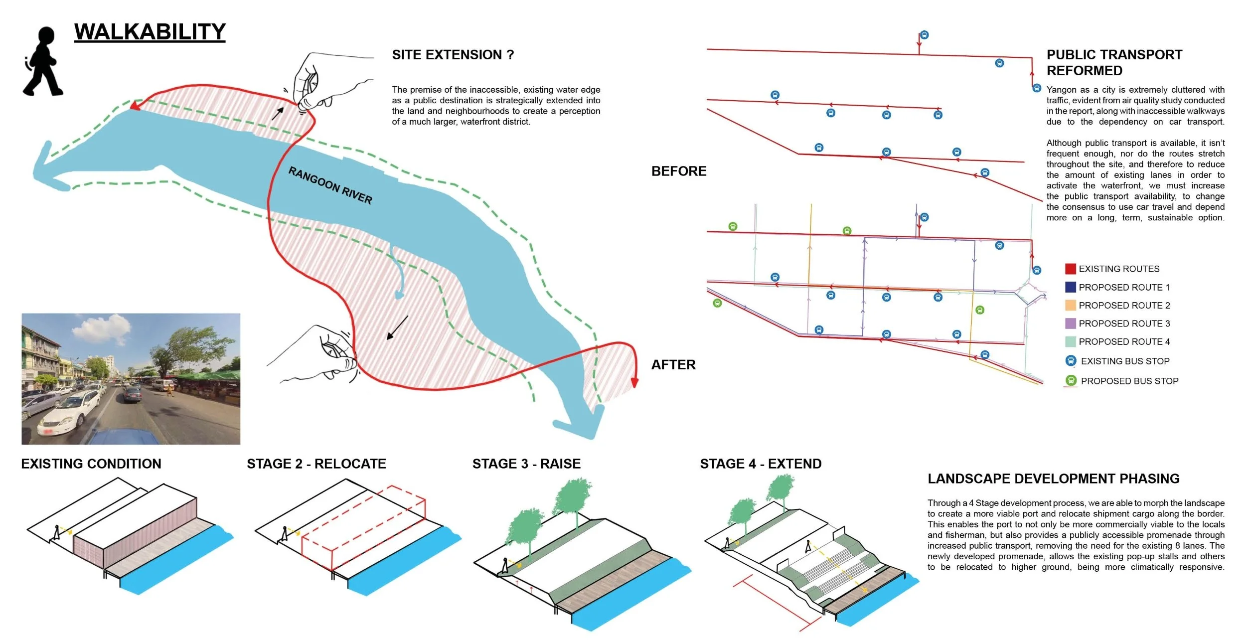
Central to the design is a robust environmental framework. Green and blue infrastructure are introduced as core elements of the public realm. A network of pocket parks, bio-swales, and flood-retention zones reactivates the ecological function of the urban landscape while improving microclimates and reducing the urban heat island effect, whilst reconnecting historical landmarks around the site. The nearby Yangon River, once a neglected edge, is re-envisioned as a public waterfront promenade and ecological buffer, promoting leisure, tourism, and community engagement.
Social inclusivity is a guiding principle throughout the project. The masterplan embeds affordable housing, flexible commercial spaces for informal vendors, and safe, accessible pedestrian zones. Cultural landmarks such as Kheng Hock Keong Temple, 19th Street markets, and Yangon General Hospital are preserved and highlighted within the urban tapestry to reinforce local identity and continuity.
From an energy and material perspective, the project champions low-impact, climate-adaptive solutions. Shading devices, breathable façades, elevated structures, and natural ventilation strategies are tailored to Latha’s tropical monsoon climate. A circular economy approach informs material choices and waste management, aiming to create a closed-loop system that benefits the environment and economy alike.
Ultimately, the Latha regeneration project envisions a future where heritage coexists with progress. It proposes an urban fabric that not only houses but empowers its residents—enhancing quality of life, celebrating diversity, and fostering long-term resilience against socio-political and environmental adversities.

Comparison of Regeneration with Alvin Kintu

Frontages with Alvin Kintu

Living Tapestries with Alvin Kintu

Adaptive Reuse with Moe Hein Aung

Bio Integration with Ömer Yılmaztürk

Public Realm Development with Ömer Yılmaztürk

Concept Development in Response to Site Constraints by Oskar Gorka
Conceptual Landscape Development by Oskar Gorka

Sectional Activity by Oskar Gorka

Waterfront Regeneration by Oskar Gorka
Transformation of Cape Town Mitchells Plain: Designing a New Future
Maryanne Johnson
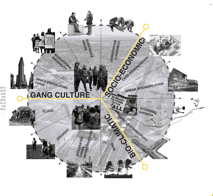
In the shadow of apartheid’s spatial legacy, Mitchells Plain offers both a cautionary tale and a unique opportunity for inclusive urban regeneration. This urban design project proposes densifying development to 800 people per hectare on a 64-hectare site in Cape Town’s southeast—without replicating the mistakes of the past.
Mitchells Plain was established in the 1970s by the apartheid government as a dormitory town for the forcibly displaced “Coloured” (mixed-race) population. Located on the sandy Cape Flats, far from the economic heart of Cape Town, its design was never neutral—it was strategic, reinforcing segregation and limiting access to jobs, services, and social mobility. Arterial roads divided communities and limited movement, embedding isolation into the area’s very layout.
This legacy remains deeply felt. The area continues to suffer from underinvestment, poor public transport, high unemployment, and territorial gang violence. Informal settlements, driven by rapid population growth and lack of affordable housing, have exacerbated the strain on already overstretched infrastructure. Thousands live in overcrowded shacks vulnerable to fire, flooding, and health risks.
But the site’s challenges are not only social or historical—they are also environmental. Mitchells Plain sits on low-lying, flood-prone land with poor drainage and sandy soils that are both drought-susceptible and flood-sensitive. Cape Town’s growing vulnerability to climate change, especially water scarcity and extreme weather, makes climate-responsive planning non-negotiable. In this context, sustainable water management, flood mitigation, and resilient infrastructure become essential components of any meaningful urban intervention.
Regeneration in Mitchells Plain must go beyond upgrading infrastructure—it must engage with spatial justice. This means reintegrating the community into Cape Town’s urban fabric and reversing decades of exclusion. Our masterplan is grounded in detailed site analysis and a deep understanding of both the ecological conditions and the socio-political history of the area. The vision is one of inclusive, sustainable growth: improving physical connectivity, encouraging mixed-use development, and ensuring access to public spaces, schools, and services.
Crucially, the project emphasizes community empowerment and long-term resilience. The goal is not to impose a solution from above, but to co-create a future with the people who call Mitchells Plain home. It is about challenging the notion that urban design is merely about form; it is about power, memory, and the right to thrive.
Mitchells Plain stands as a testament to both systemic harm and community strength. With thoughtful, climate-aware planning and a commitment to equity, it can become a model for how South African cities reckon with their past while building more just and sustainable futures. Regeneration here is more than spatial—it is social, environmental, and deeply political.
Group work contributors-
Aisha Abubakar, Aditya Chongtham, Ege Ersoy, Maryanne Johnson, Enkyin Oo
Design framework - Group work

Master plan - Group work
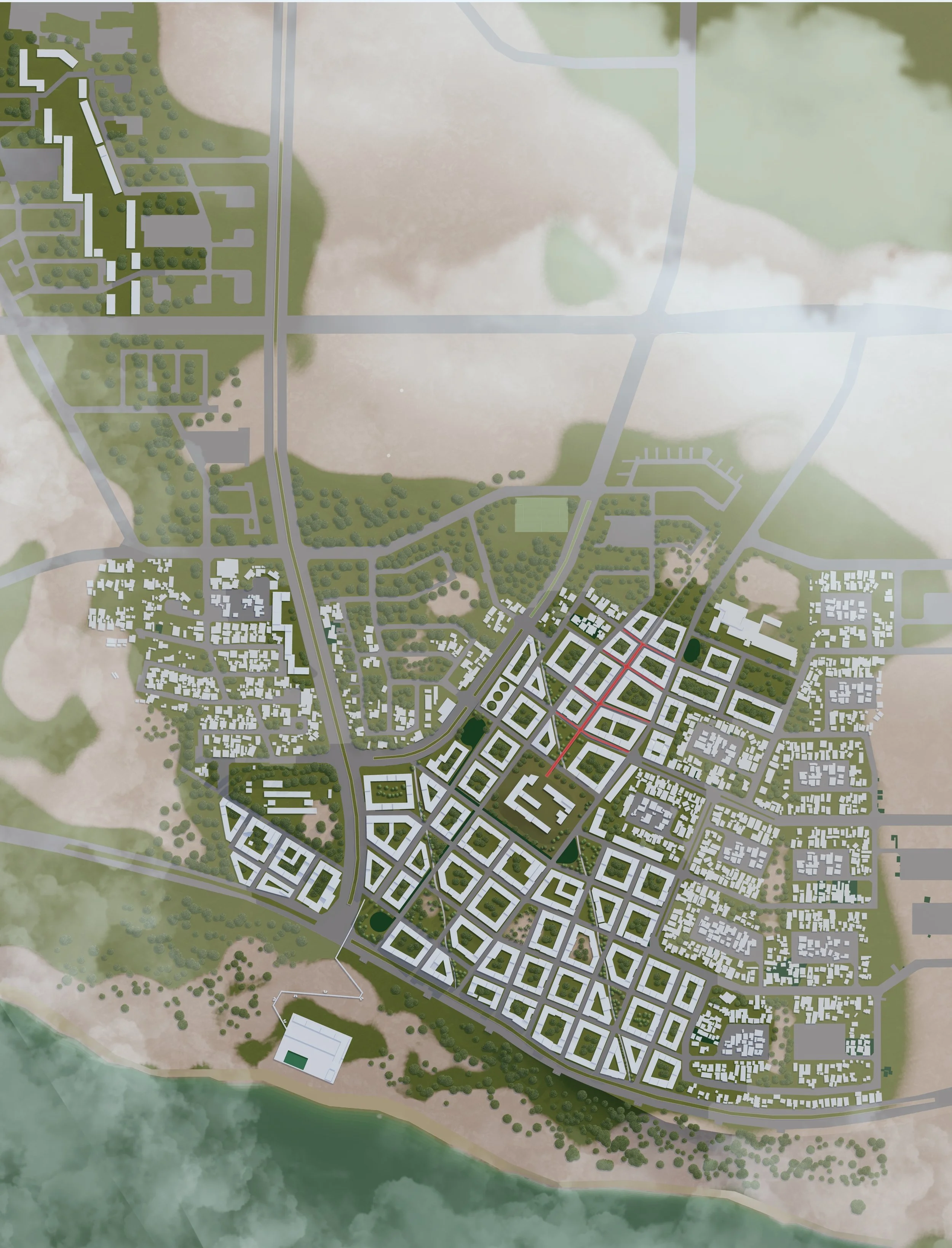
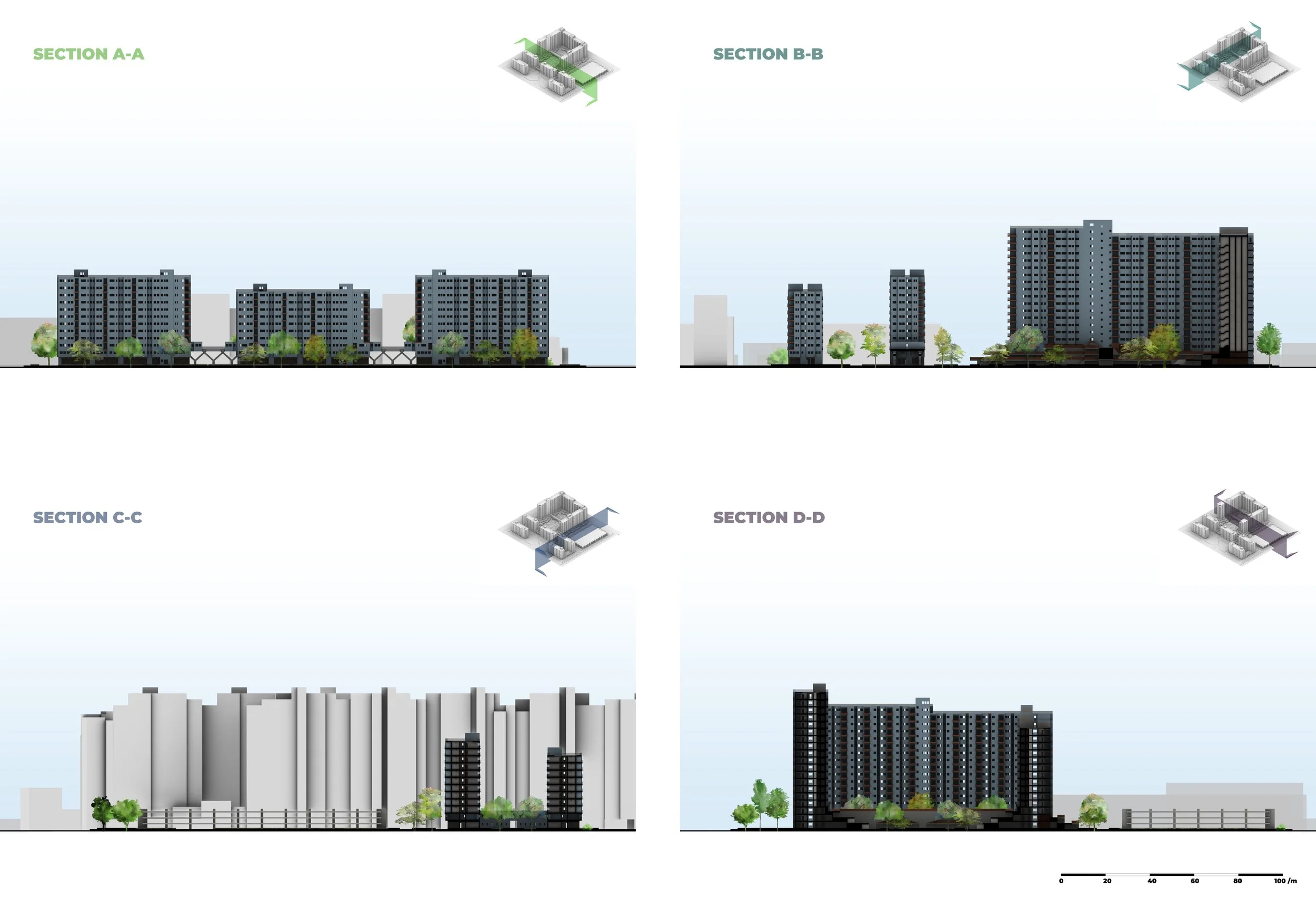
Masterplan - Group work
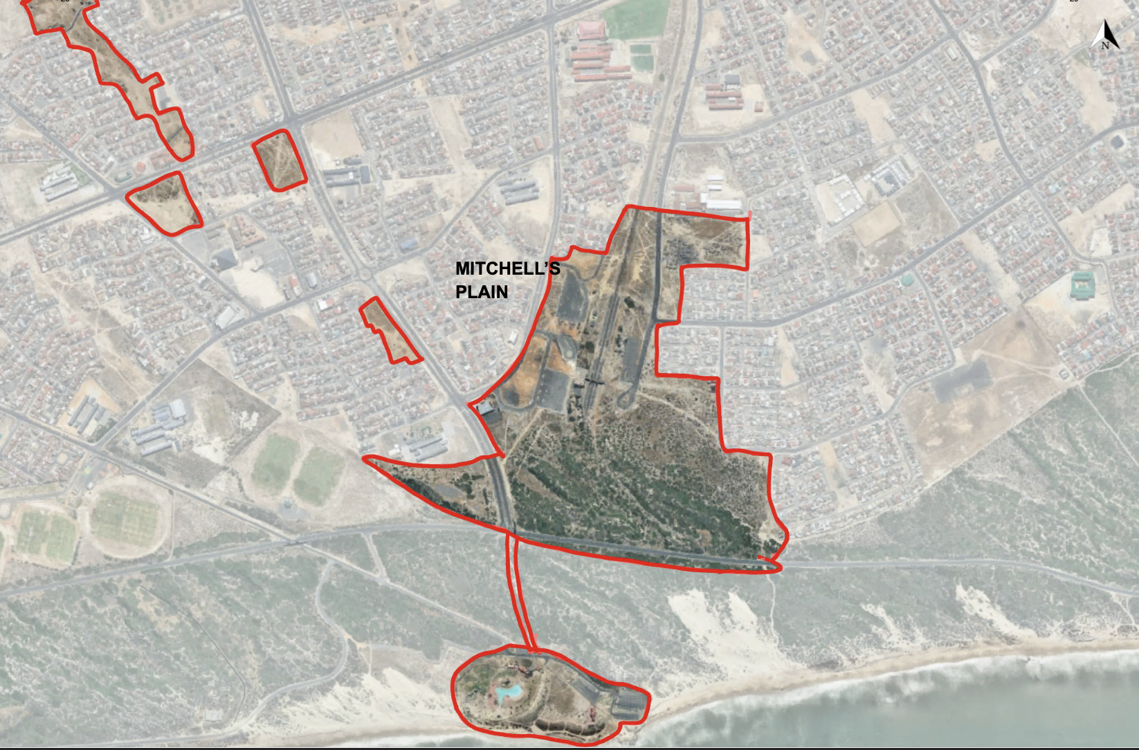
Site location - Group work

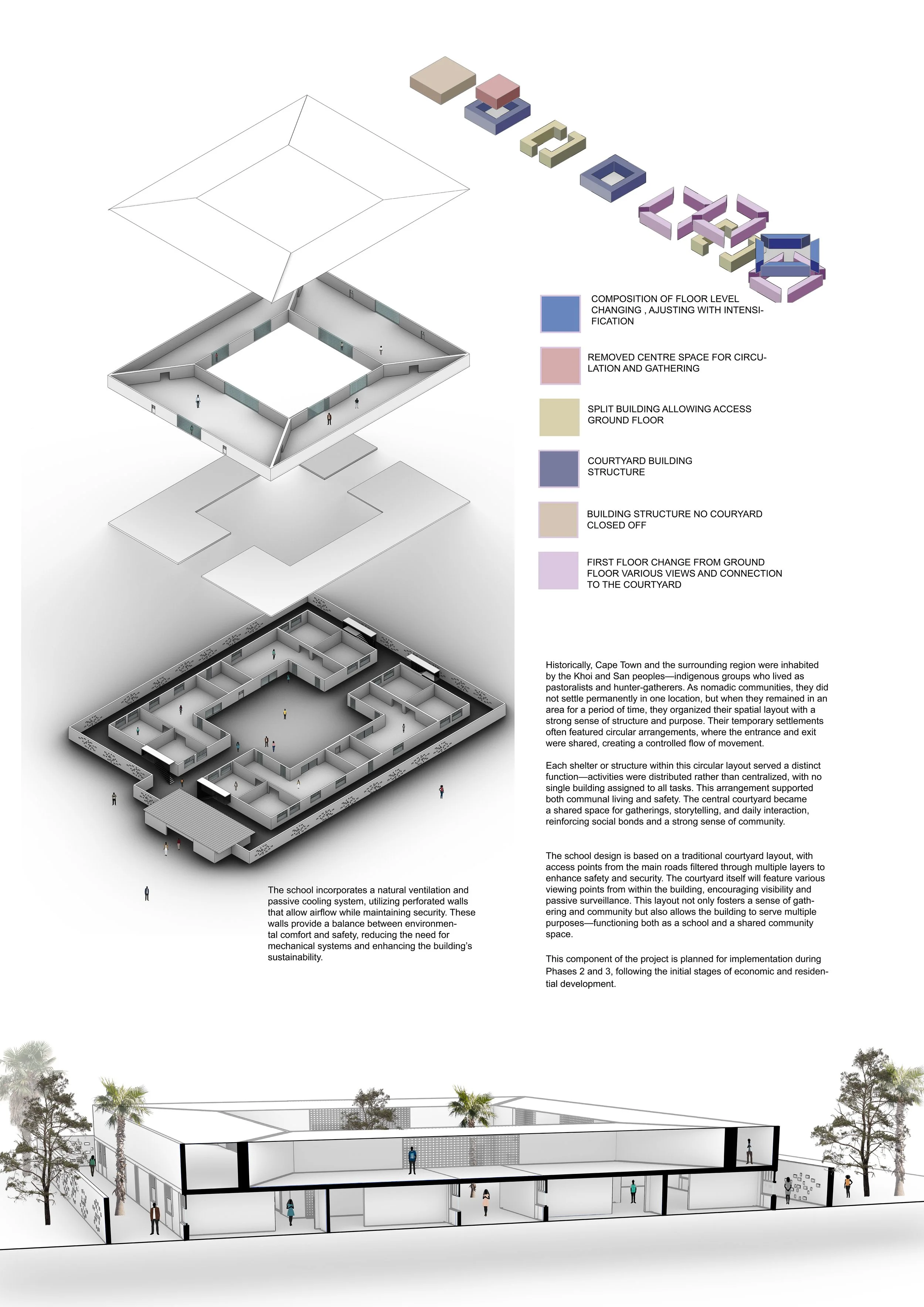
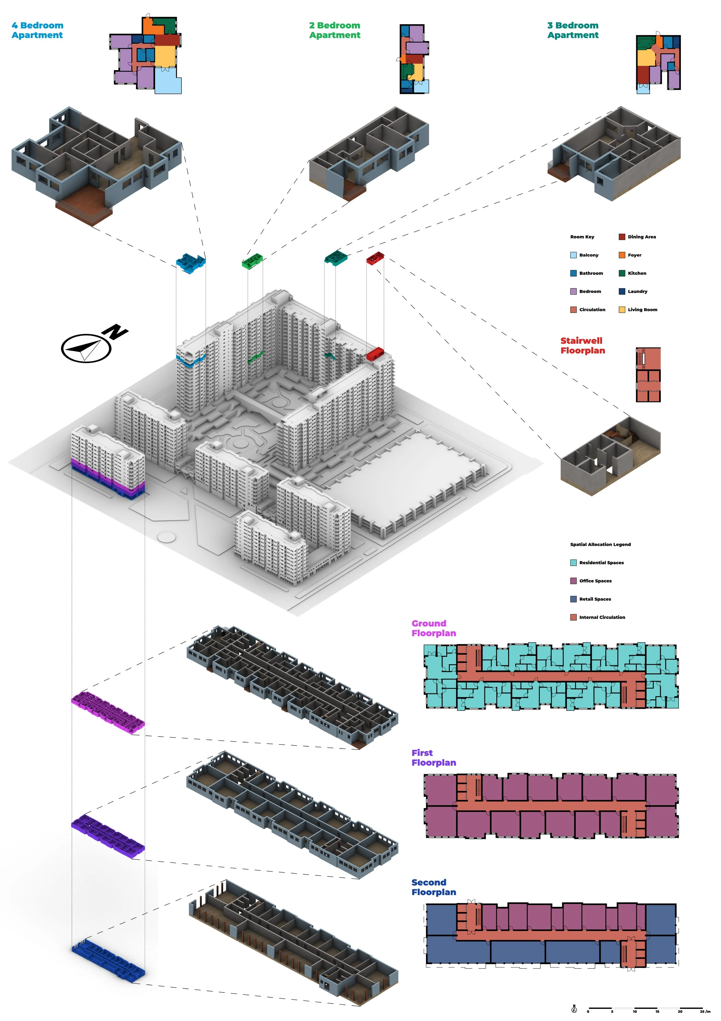
2 buildings by Aisha Abubakar

Concept by Aisha Abubakar

Floorplan Phasing by Aisha Abubakar

Market and Plaza by Aisha Abubakar

Master Plan Phasing by Aisha Abubakar

Pavilion by Aisha Abubakar

Pavilion seating by Aisha Abubakar

Public realm and museum by Aisha Abubakar

Residential zone by Aisha Abubakar
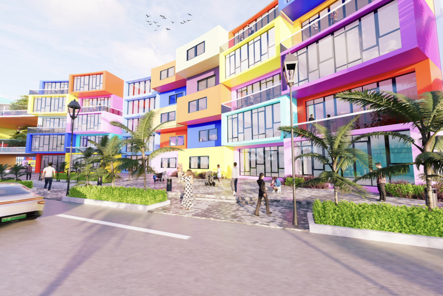
Street View by Aisha Abubakar

Comic scene - Block design by Maryanne Johnson

Comic scene2 - Block design by Maryanne Johnson

Design Sketches by Maryanne Johnson
Typology study by Maryanne Johnson

Typology study by Maryanne Johnson
Intensification of Industrial Saint-Denis, France
Léonor de Vazelhes
Located just north of central Paris, Saint-Denis is a district steeped in history and cultural complexity. Once a royal burial ground and now one of France’s most diverse and economically deprived areas, the neighbourhood faces multifaceted challenges including social inequality, high crime rates, and environmental degradation. The “Creactive Revitalisation” group project presents an ambitious vision for transforming this marginalised suburb into a dynamic, inclusive, and resilient urban environment.
The project responds to the unique socio-cultural and physical context of Saint-Denis, especially in the wake of the 2024 Paris Olympics, which brought international attention and infrastructural investment to the area. The primary aims are to repair the fractured urban fabric, celebrate the area’s cultural identity, and ensure that regeneration benefits the existing population rather than displacing it. At the heart of the proposal is a commitment to equitable urban design that supports economic opportunity, enhances safety, and promotes environmental sustainability.
The architectural strategy adopts a people-first approach, rooted in the principles of the 15-minute city. The masterplan reimagines Saint-Denis through a hierarchy of well-connected, pedestrian-friendly spaces that reduce car dependency and prioritise active travel. Key interventions include a redesigned mobility network, integration of blue and green infrastructure, and a reallocation of land to support diverse building typologies and public uses. Public spaces are activated with cultural venues, community centres, and sports facilities that reflect the needs of Saint-Denis’s vibrant, multicultural population.
Careful attention is given to maintaining and enhancing the character of the district. This is achieved by preserving historical landmarks such as the Basilica of Saint-Denis, promoting local street art, and supporting music festivals and religious celebrations that define the community’s identity. Architectural elements are designed to reflect the area’s heritage while introducing modern, adaptable structures that can evolve with future needs.
Sustainability is a core pillar of the proposal. The plan incorporates nature-based solutions to mitigate urban heat and pollution, including green corridors, rain gardens, and permeable surfaces. Passive design strategies are employed across building forms, with orientation and material selection aimed at maximising energy efficiency. Mixed-use zoning ensures that workplaces, homes, and amenities are co-located, reducing the need for long commutes and supporting local economies.
The scheme also addresses broader systemic concerns, such as housing affordability and social cohesion. New developments are planned to offer a mix of housing types, including family units, co-living spaces, and retirement accommodations. Public spaces are designed to foster safety and inclusivity, applying Crime Prevention Through Environmental Design (CPTED) principles to encourage natural surveillance and community ownership.
In sum, the Creactive Revitalisation of Saint-Denis offers a blueprint for socially responsive and environmentally sustainable urban regeneration. It repositions a historically marginalised district as a model of inclusive design, one where cultural richness and community needs guide architectural innovation and urban planning.
The group masterplan was subsequently developed through individual contributions, with each team member selecting three blocks to refine in detail, guided by a specific theme. Keny Patel’s design explores the concept of a 24-hour mixed-use hub, envisioned as a safe and vibrant transitional space that supports continuous activity and community engagement. Léonor de Vazelhes focuses on intergenerational co-living, aiming to combine integration, safety, affordability, and sustainability. The approach identifies overlapping needs among diverse user groups, proposing mutually supportive shared spaces that enhance connectivity and create a strong sense of community.

GF Plan by Keny Patel

Night Section by Keny Patel

Village Lumiere Axo by Keny Patel.

Proposed Masterplan by Keny Patel, Léonor de Vazelhes, Alice Barnes, Sarah Heppell

Vision Framework and Hierarchy by Keny Patel, Léonor de Vazelhes, Alice Barnes, Sarah Heppell

Public Realm Ground Floor Plan by Leonor de Bronac de Vazelhes

Co-Living Section by Léonor de Vazelhes
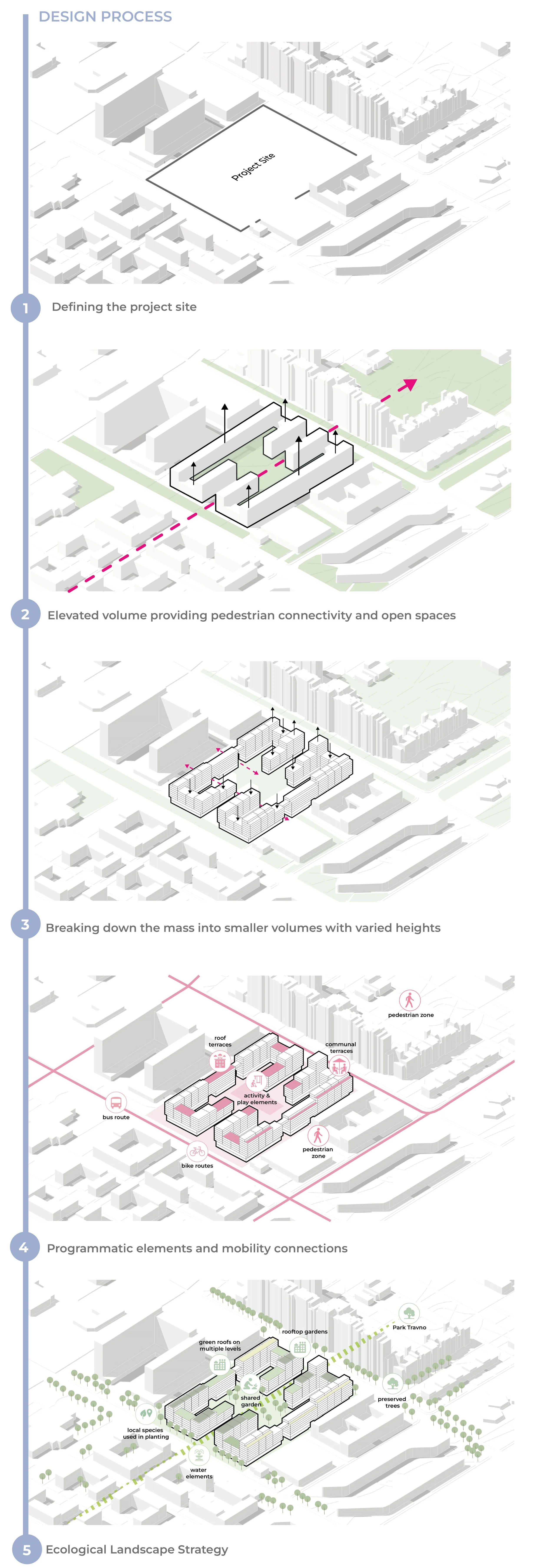
Regenerating Travno- A Connected Urban Framework for Living, Culture, and Filmmaking
Melisa Sarisu
This urban design project investigates how large-scale post-socialist housing estates can be reimagined to respond to contemporary urban challenges. Set within a 64-hectare area in Travno, a neighbourhood in the south-eastern part of Zagreb, the project responds to issues of disconnection, declining public spaces, outdated infrastructure, and a lack of spatial cohesion. The goal was to propose a holistic urban regeneration strategy that supports walkability, enhances public life, and fosters long-term adaptability.
The initial phase of the project involved in-depth site analysis, exploring the spatial morphology, land use patterns, street hierarchy, and socio-demographic conditions. The study revealed that the existing structure, shaped by modernist planning, had produced large, disjointed areas with limited pedestrian flow and fragmented public space. Residential superblocks with low activity on the ground floor contributed to inactive, monofunctional environments. Additionally, there was a noticeable lack of mixed-use development and a mismatch between spatial scale and human needs.
The masterplan introduces a new grid and path system to reconnect isolated areas and create a more walkable and structured urban layout. These new routes form a coherent circulation loop, anchored by public spaces strategically distributed across the site. The design introduces a central public spine that links key nodes, creating vibrant focal points for gathering, cultural activities, and daily social interaction.
One of the key strategies was to reorganise the plot structure, introducing smaller, more flexible land parcels to support a diverse mix of programmes. This restructuring enables future development phases to respond incrementally to changing social and economic needs. Meanwhile, selective infill development and repurposing of underutilised areas promote compactness without compromising existing green spaces.
The plan also focuses on enhancing the quality of public life. Existing open spaces are transformed into multifunctional community areas with clear edges, better accessibility, and active ground-floor uses. To support this, the spatial relationship between fronts and backs of buildings was redefined to strengthen their connection with public space and ensure more active and meaningful street frontages.
Environmental sensitivity underpins the overall approach, integrating green infrastructure such as tree-lined walkways, bioswales, and open water elements. The strategy supports resilience to heat and rain while improving the overall visual and ecological quality of the urban environment.
Ultimately, the project envisions Travno not as a closed residential enclave, but as an adaptable, connected urban quarter. By addressing issues of fragmentation, spatial monotony, and social isolation, the design offers a framework for gradual transformation that respects the site's history while enabling a vibrant, accessible, and sustainable future for Zagreb.
Residential Typologies and Axonometric View by Alex Malone
Section Drawings-Building Scale and Massing by Alex Malone

Travno Masterplan Strategy Diagram-Programme Distribution and Key Interventions - Group Work

Travno Proposed Masterplan - Group Work

Film-Oriented Student Living and Production Hub with Kelvin Osei Tutu

Synergetic Living-Views From Common Areas with Kelvin Osei Tutu

Block Division and Connectivity
Concept Development-Urban Form, Mobility and Ecology

Typical Floor Plan - Layered Public Realm and Activity Network

Urban Framework for Filmmaking-Land Use, Spatial Strategy and Cultural Spaces with Qin Kae Wong